Showing posts with label Google. Show all posts

Tuesday, December 13, 2011

Seamless Topographic USGS Maps on Google Earth


On November 30 the Google Earth Blog released the following post:

Seamless Topographic USGS maps
A few months ago we showed you Matt Fox's excellent topographic maps of New Zealand, which were quite impressive. Over the years he's had many requests to create similar maps with seamless USGS topographic data, and now he's starting to roll them out on his site.

flat-ridge.jpg

As you can see from the image above, the maps are remarkably sharp. The are distributed through a rather unique system; rather than just downloading a KMZ file, you download an installation program that adds the maps to your PC as Super Overlays. To try it for yourself, Matt is offering a free download of the San Francisco area, available here.

For comparison, you can check out our "best topo map interface" post from 2006 (a free service of USGS topo maps for the US). While they were impressive five years ago, the new maps are significantly higher quality.

comparison.jpg

For more, be sure to visit Google Earth Library and read Matt's full blog entry.

Looks like a very interesting addition to the Google Earth Library, and one that will be very useful going forward.

Wednesday, November 30, 2011

A New Frontier for Google Maps: Mapping the Indoors

The Google LatLong Blog today had this great post about the most current technology adoption for Google Maps:


“Where am I?” and “What’s around me?” are two questions that cartographers, and Google Maps, strive to answer. With Google Maps’ “My Location” feature, which shows your location as a blue dot, you can see where you are on the map to avoid walking the wrong direction on city streets, or to get your bearings if you’re hiking an unfamiliar trail. Google Maps also displays additional details, such as places, landmarks and geographical features, to give you context about what’s nearby. And now, Google Maps for Android enables you to figure out where you are and see where you might want to go when you’re indoors.


When you’re inside an airport, shopping mall or retail store, a common way to figure out where you are is to look for a freestanding map directory or ask an employee for help. Starting today, with the release of Google Maps 6.0 for Android, that directory is brought to the palm of your hands, helping you determine where you are, what floor you're on, and where to go indoors.


Detailed floor plans automatically appear when you’re viewing the map and zoomed in on a building where indoor map data is available. The familiar “blue dot” icon indicates your location within several meters, and when you move up or down a level in a building with multiple floors, the interface will automatically update to display which floor you’re on. All this is achieved by using an approach similar to that of ‘My Location’ for outdoor spaces, but fine tuned for indoors.

Mall of America in Minneapolis before and after, with a floor selector

San Francisco International Airport before and after, with 3D tilt

We’ve initially partnered with some of the largest retailers, airports and transit stations in the U.S. and Japan, including:
  • Mall of America, IKEA, The Home Depot, select Macy’s and Bloomingdale’s, Daimaru, Takashimaya and Mitsukoshi locations and more. Watch an IKEA demo here.
  • Hartsfield-Jackson Atlanta International Airport (ATL), Chicago O’Hare (ORD), San Francisco International Airport (SFO) and Narita International (NRT), among others.
  • JR and Tokyu Corporation
For a detailed list of participating locations, please visit our help center. And this is just the start--we’ll continually add new indoor maps to public buildings across the world. If you’re a business owner interested in getting your location’s floor plan included in Google Maps, visitmaps.google.com/floorplans.

We’re thrilled Google Maps continues to provide you with new and helpful perspectives—whether you’re rushing through the airport or finding your way around a mall. To visit our website and learn more about indoor Google Maps and other features, start here.


Thursday, October 13, 2011

Step Inside the Map With Google MapsGL

Brian McClendon, VP of Google Maps and Earth posted a great post today on the Google LatLong Blog explaining the Google Maps Graphics Library (GL) capabilities.  Pretty neat stuff!


You’re now one step closer to experiencing and interacting with a 3D mirror of the real world within your browser withGoogle MapsGL. Google MapsGL takes Google Maps and harnesses the power of Web Graphics Library (WebGL) to create far richer visuals and animations.

WebGL is a new technology that brings hardware-accelerated 3D graphics to the browser without additional installed software. With WebGL your maps experience is much better with 3D buildings, smoother transitions between imagery and the ability to instantly “swoop” into Street View without a plugin.


Starting today, if you’re using supported browsers (such as Chrome 14+ or Firefox Beta) with compatible video cards, you can opt in to the early beta release. Visit maps.google.com and click “Try it now,” or visit maps.google.com/gl to learn more.

We’ve been using WebGL to create experiences like our Chrome experiments “3 Dreams of Black” and “All is Not Lost,” which happen right in the browser. Previously, such sophisticated 3D graphics have only been possible on traditional desktop applications and have required manual installation. WebGL ushers in a whole new generation of graphics on the web, and with that, we can begin to redefine the expectations of an online map.

Check out Chrome Experiments WebGL for more WebGL-powered applications, and opt in to Google MapsGL to begin using the next generation of mapping today.

Tuesday, October 4, 2011

Geo APIs Summer Learning Series: Map Your Business, Inside and Out

Google posted this great video and update last week on their GeoDeveloper’s Blog about the Google Maps API:


http://googlegeodevelopers.blogspot.com/2011/09/geo-apis-summer-learning-series-map.html

They sure have some great stuff and smart people at Google.

SlashGeo Poll: Esri ArcGIS Online vs Google Earth Builder?


SlashGeo conducted a poll to find out which platform people preferred with regard to the ESRI ArcGIS Online vs Google Earth Builder debate.  The results are totally split.  Here are the results of the poll:

ESRI ArcGIS Online will prevail:  24%

Google Earth Builder will prevail: 24%
Both will be successes in their own way: 42%

Microsoft Bing Maps will rule them both: 2%

VerticalGeo is an avid user of both ESRI and Google Products.  This poll should have been a little more explicit in the question it asks.  ArcGIS Online and Google Earth both both do a great job with the presentation tier when producing geospatial data.  Neither do a very good job with the data authoring tier when producing geospatial data.  As far as VerticalGeo is concerned the ESRI suite of software products can’t be beat with it comes to authoring geospatial data.  The ESRI suite of software tools though is very expensive.  I believe there will soon be a proliferation of open-source geospatial creation and presentation tools that will compete against both ESRI and Google Earth.  What we really need if we want to develop a geospatial powerhouse are the robust tools that ESRI provides with the open source pricetag.

VerticalGeo will be venturing more deeply into the open source market to help provide just that.  We intend to combine cloud computing, open source tools for geospatial data authoring and maintenance, with a top notch presentation layer, all with a web-based interface, for free, in an attempt to help guild a community of geospatial users that will have a new alternateive to the ESRI vs Google Earth debate.

Sunday, October 2, 2011

Helicopter view of your driving directions on Google Maps

Thanks to Google's LatLong Blog for posting this on Friday:

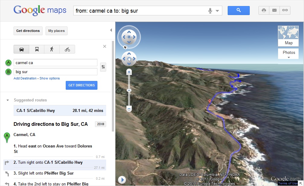
Getting directions is one of the most popular features on Google Maps, whether it be for driving, walking, biking or transit. Today, we are launching a new feature that allows you to bring your upcoming trip to life, by allowing you to preview your route in 3D.

Let’s say you’re planning a road trip down the beautiful coast of California’s Highway 1 and want to be able to see what the route really looks like. California’s rugged coastline is not to be missed, but the top-down view really doesn’t give you a good sense of what this majestic terrain is like. Using the 3D preview; however, you can get aerial view of the route, as if you were in a helicopter flying above the road.


To preview your own route, it is as simple as clicking on a button. Start by entering your starting point, destination, and mode of transport like any directions; in this case, driving directions from ‘Carmel CA to Big Sur CA.’ Then, just click on the “3D” play button. The map will switch to Earth view and automatically start flying you along your recommended route.


You can pause the flight at any time by clicking anywhere in the 3D view or on the pause button in the lower left. While the flight is paused, you can explore the surrounding area in 3D by clicking and dragging the map. When you are ready to resume the flight, simply click on the play button in the lower left of the 3D view.

To help you keep track of which step you are on, the current leg of the trip is highlighted in the left panel. You can also jump to a different part of the trip by clicking on a different step.


You can get back to 2D mode by clicking on the “2D” button in the left panel at any time.

We hope you enjoy your flight.

Monday, January 29, 2007

Google Tailors Earth For DOD Users

Here's a great article on how Google Earth is creating the ability to fuse geospatial information layers for visualization purposes for the US Department of Defense. Link.

I'll have to admit, even as a die-hard former ESRI employee, that the Google Earth visualization platform is hard to beat. It is simple and easy to use, provides a good viewing tool, and Google seems to be able to responsively make changes to Google Earth rapidly to meet customer's needs. But, it still isn't useful as an analysis tool like ESRI's ArcGIS is. The DOD executive decision makers may be asking for Google Earth to help them visualize the information needed to make the tough decisions, but most of the information creating the layers behind what they see comes from ArcGIS users.

ESRI is marketing a Google Earth-like viewing platform that will work well with ArcGIS 9.2 called ArcGIS Explorer that blends good visualization tools and detailed analysis capabilities, but it still isn't quite there. I played with it extesively last week and it still has some bugs in it. ESRI is trying to compete with Google Earth, and it is sad to say, but I believe as the Google organization gets bigger and more cumbersome it should be easeir for ESRI to compete in the viewer market.